Aside from snow and
onsens (hot springs), another one regular blessings that the Niseko zone has
been honored with, is the wealth of mineral drinking water springs.
16) 阿寒国立公園オンネトー【足寄町】Akan National Park Onneto [ Ashoro ].
Akan National Park is a
volcanic region with bowls on land spread all through the woodland. It
additionally contains three completely clear lakes. The zone encompassing these
lakes is secured with woods and dotted with hot springs.
Ningle is a 15cm height fairy that lives in the forest that believed by Ainu people, Ningle also appeared to be a title of a book, and also known as (The Wisdom of Forest) from its original meaning.
This probably is the latest news on my blog, I post this at 10/25/2016 if you read this post at this date, means you still have about 5 days chance to visit this wonderful Jozankei Nature Luminarie. The Jozankei Onsen is currently celebrating their 150th anniversary and they are lighting up the forest park, from the Futami Koen until the Futami bridge, Opening every evening on 6/1-10/31 this year.
Talking about Hokkaido,
it gives everybody a solid picture of winter, yet you can't disregard the
spring when numerous flower begins blossoming after the winter has passed.
Other than the season special, there are so much more to see, especially the
national park and hiking trail, which is not so often travel by foreign
visitors. At here, most of the recommended places come with how to access, of
course, by public transport. A solo traveler like me has no use with the car,
besides, I can't drive >.<.
During my
travel, the information which I gather during my planning usually is not enough
and sometimes things and place are changed over time, by the time I reach the
oversea, access to the destination is always the most headache problem for me,
furthermore, I am not good to speak Japanese. At this post, I try to make this
post detailed, especially the access part, I hope you enjoy watching at the
picture and this post help you to plan your trip to Hokkaido, to where the
Magnificent view is located at.
Below is my 25
Magnificent view in Hokkaido, Japan.
1) 旭岳、沼の平【旭川】
Asahidake, Flat Swamp [
Asahikawa ].
2) 大雪山高原沼めぐり【旭川】
Daisetsuzan Kōgen
Numa Meguri [ Asahikawa ].
3)ラベンダー畑【富良野町】
lavender Batake [
Furano-cho ].
4)アーチ橋「タウシュベツ橋」【上士幌町】
Arch Bashi "Taushubetsu
Bashi" [kamishihoro].
5)三国峠【上士幌町】
Mikuni Toge
[kamishihoro].
6) 雲海テラス【トマム】
Unkai terrace [ Tomamu
].
7) 美瑛の青い池【美瑛町】
Biei No Aoi Ike
[Biei-cho ].
8) 美瑛の丘&パッチワークの路【美瑛町】
Biei No Oka &
Patchwork No Michi [Biei-cho ].
9) 石山緑地【札幌市】
Ishi Yama Ryoku Chi
[Sapporo].
10) カムイワッカ湯の滝【斜里町】
Kamuiwakk- Yu No Taki
[Shari-cho ].
11) 知床五湖【知床】
Shiretoko Go Ko [
Shiretoko ].
12) 能取湖サンゴ草群落【網走市】
Notoro Ko Sango Gunraku
[ Abashiri ].
13) オホーツク海の流氷【網走市】
Okhotsk Kai No Ryuhyo
[Abashiri].
14) オロロンライン【小樽市~稚内市】
Ororon Line [ Otaru -
Wakkanai ].
15) 摩周湖【弟子屈町】
Mashu Ko
[Teshikaga-cho].
16) 阿寒国立公園オンネトー【足寄町】
Akan National Park
Onneto [ ashoro ].
17) 神威岬【積丹町】
Kamui Misaki [ shakotan
].
18) 東藻琴芝桜公園【大空町】
Higashimokoto
Shibazakura Koen [Ozora-cho].
19) 宗谷丘陵【稚内市】
Soya Kyuryo [ Wakkanai
].
20) ひまわりの里【北竜町】
Himawari No Sato
[hokuryu].
21) ふきだし公園【京極町】
Fukidashi Koen
[Kyogoku-cho].
22) 地球岬【室蘭市】
Chikyu Misaki [Muroran].
23) 二十間道路桜並木【新ひだか町】
Nijukken Doro Sakura
Namiki [Shinhidaka-cho].
24) 函館山【函館市】
Hakodate Yama [ Hakodate].
25) 大沼国定公園【七飯町】
Onuma Quasi-National
Park [Nanae-cho].
1) 旭岳、沼の平【旭川】Asahidake, Flat Swamp [ Asahikawa ].
As you can see, Numa No Hira, The Flat Swamps.
Hokkaido’s Mt. Asahi, is the tallest volcano in the region and is
also a home to various ponds and lakes in the high-elevation marshlands. Numa
no Hira signifies "Flat Swamp" in Japanese, is formed by the various
size of swamps and ponds, from large, medium, and small, this wetland is huge
and is about 1300 meters in size which are enough to raise your heartbeat by
just look at a glance. The photo is taken during the season of Autumn.
The path near the observation deck.
The Asahi Dake is the
only and earliest place in Japan where to welcome the Autumn the first, hence, you can see the Autumn scene along
with your hiking way to the Numa no Hira, enjoy the mystical beauty of Autumn
earlier than anyone in Japan. The Mount Asahi is loaded with visitors during
September, which is the time when The Asahi Dake turn itself into Autumn, where
trees, grass, and leafs are wearing the Autumn costume, forming a contrast
stunning view of red, yellow, and cobalt blue around the mountain.
The Honey and Hubby swamps.
Numa No Hira is deep in
the Mt. Asahi and it takes about
3 hours to go through the hiking trail before you can meet the lovely swamp, I
suggest you train yourself before you challenge this mystery hiking. Other than
that you can also infuse yourself in the wonder of Asahi Dake around the Asahi
Dake Ropeway, where offering you another lovely swamps and scene.
There is a
strolling course around the Asahi ropeway, leading you to the Kagami pond and
Suribachi pond, These two ponds are also known as the Metro Pond (Wife and
Husband), then, the Sugatami pond where you can take the photo of steam created
by the volcano nearby. The strolling course comes with observation deck, easy
for you to take some picture, and finish one round of the course is about 1
hour.
Best visit during Autumn.
The hiking route is best
to visit depend on the season, for example, it is best to stick with the strolling course
around the ropeway station during summer, while it is best to explore the Numa
No Hira during the Autumn. Finally, as for the Winter, challenge with your
vitality, because the environment is harsh and dangerous, however, you may
explore the Sun pillar and the Diamond dust during winter, when the temperature
is below -15°C.
The Numa No Hira is three hours walk away from the Ropeway.
Name:
旭岳、沼の平【旭川】Asahidake, Flat Swamp [
Asahikawa ].
Address:
Sounkyo
Kamikawa-gun, Kamikawa-cho (Numa No Hira.)
Click here for
the Ropeway time table , it is a
massive one :).
Fare:
The fare vary
by season, check with the link above (the Asahi Dake ropeway site.).
Phone:
0166-97-2153
Asahi Dake visitor center.
2) 大雪山高原沼めぐり【旭川】 Daisetsuzan Kōgen Numa Meguri [ Asahikawa
].
This is a hard travel, but it is worth to go a time.
Daisetsuzan Kogen Numa
Meguri is a hiking route to the various ponds and swamps (Numa) in the Mount
Asahi, where you can enjoy the
superb view of the Autumn Mount Asahi. A clear blue sky, comfortable breeze,
magnificent mountains and fall foliage could be enjoyed.
This is the biggest swamp, Daigaku Numa.
Every pond have their
own unique size and scene,
you may feel bored after a few hours walk, but soon you will find out the
wonder of the pond as you approach the highest pond, the Kogen Numa, a pond
surrounded by outstanding fall foliage. Other than the trees and leafs, you may
also encounter some active deer or some lovely birds, and the most dangerous
one, the Brown Bear, but fear not, there is staff nearby guide you around and
away from the dangerous bear.
This is Kogen Numa, The highest point of the trail.
Daisetsu Kogen Onsen (大雪高原温泉, Daisetsu Kogen Onsen) is one of the multiple
bases from where Daisetsuzan National Park can be explored, and they opened for only 123 days. Located at
1260 meters above sea level, the small, remote base on the eastern side of the
national park consists of just a single accommodation with hot spring baths and
is connected to the main road by a ten kilometer, unpaved road.
The Daisetsu Kogen Onsen
in the southern part of Kamikawa town. There is the Brown Bear Information
Center on the opposite side of the Daisetsu Kogen Onsen's building and this is
an entrance of the Daisetsu Kogen Onsen Hiking Tour. Because the area is a nest
of brown bears, hikers need to attend a short lecture at the bear information
center before setting off. Walking the entire trail takes about five hours and
requires no advanced hiking skills or equipment.
I see different color.
The staff is out on the
track each day, radioing in bear whereabouts and keeping an eye on both the
hikers and the bears. This is a
wonderful day hike beneath the high peaks. Hikers are only allowed to head out
on the hike between 7am and 1pm. Hikers must be off the track by 3pm.
A separate hiking trail
leads from Daisetsu Kogen Onsen to Mount Midoridake (3 hours one way), from
where well-prepared hikers can continue hiking into the vast interior of the
Daisetsuzan mountains.
There are only three
designate ponds/places that allowed to eat, they are Midori-Numa, Daigaku Numa, and Kogen Numa, so, get
ready your lunch box and drinks in your back pack before you begin your hiking.
On the way back to Onsen Inn.
Name:
大雪山高原沼めぐりDaisetsuzanKogen-numaMeguri.
Address:
Sounkyo, Kamikawa, Kamikawa District,
Hokkaido Prefecture 078-1701, Japan
There are seven direct buses per day from Asahikawa Station to Sounkyo (110 minutes, 2100 yen one way).
1) Alternatively, you can ride a JR train to Kamikawa
Station (40 minutes, around 2000 yen by limited express train or 70 minutes,
1070 yen by local train from Asahikawa) and catch a bus from there (30
minutes, 870 yen, 11 buses per day).
2)Once you reach
the SounkyoOnsen, take a
taxi or take a free shuttle bus provided by the OnsenRyokan (Some of them may provide), reservation
needed, you can check with the link above or use the phone number below to
call for a reservation.
Business hour:
10:30-17:00
Regular closing day from October 11 to June 09
Fare:
The fare of Onsen Inn is different for each occasion, check this
link for more information, this link is only available in Japanese but
you can use google translate, the result is still able to understand easily.
Phone:
(01658)5-3818 for the Onsen Inn reservation.
(only available from 10th of June until 10th of October.)
(0166)26-8300 For the shuttle bus reservation and winter contact.
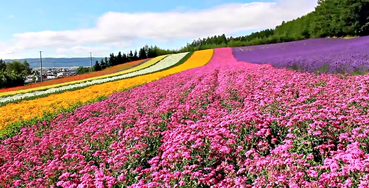
3)ラベンダー畑【富良野町】lavender Batake [ Furano-cho ].
Do you like Lavender,
love the way they swing in the wind?
Do you like lavender? Envision yourself strolling through an
enormous stunning floor covering of blossoming lavender in Provence. The sweet
flower fragrance of the herb calming your nerves, taking every one of your
stresses far away, and just the humming of the honey bees breaking the quiet.
Welcome to Farm Tomita.
One of the oldest lavender
fields in Japan, this is the place
where Farm Tomita initiate its first step in lavender
cultivating. The field was picked as an area for a photograph calendar created
by Japan National Railways (as of now the Japan Railway Company). That was the
springboard for the lavender fields in Furano to wind up known across the
nation.
Travel to France is too
much for your budget? I got an Idea for
you. Go to Hokkaido, the biggest Japanese prefecture, in July! Lavender has
been developed there for over 50 years. The Furano farms are similarly famous
to both Japanese and foreigners. Lavender is in full blossom around the middle
of summer and numerous bloom celebrations are held each year. Return to the
very same place to enjoy the ski resort.
A purple carpet of
lavenders spreads over the slope. Strolling the slope to the highest point of the field brings
you views of awesome wonder. Beyond the lavender flowers swaying in wind are
the rural landscapes of the Furano valley and the Tokachi Mountains.
The rest area with various facilities.
Among the most prevalent
lavender-themed desserts and beverages are lavender honey caramel custard, lavender jelly,
lavender-flavored cheesecake, lavender smoothie, lavender lemonade and lavender
soft-serve ice-cream, each of them is healthy as well as extremely delicious.
Lavender-scented candles, lavender oil, lavender cosmetics and different
trinkets are likewise flourishing.
Try to avoid the day of
festival and weekend if you want to avoid crowds. The best visit timing may
change over time, check the website below before visit.
There are other flowers too.
Name:
ラベンダー畑【富良野町】Lavender
Batake [ Furano-cho ].
Address:
Kisen Kita 15-go, Nakafurano-cho, Sorachi-gun, Hokkaido
25 minutes walk from the Naka Furano
station, or 7 minutes walk from the lavender farm station, for more
information, please click here, Farm tomita
access.
Business hour:
Mostly 9am to 5pm to all the shop and facilities. May change depend on
season.
The Taushubetsu Bridge was raised in 1937 and is a piece of the
first elevated railroad bridges that turned into the first designated Hokkaido
Heritage, the Old National Railway Shihoro line Concrete Arch Bridges.
Although initially all
the arches were set to be disassembled after the line was shut, numerous nearby
citizens felt that these extensions had more to offer and started a
conservation development to preserve them. Taking all things together, 34
bridges have been protected. Since 1999 the community has attempted to develop
and promote the bridges as a centerpiece of the region. They made the
"Higashi Taisetsu Arch Bridge Association" to help in this exertion.
Soon the water comes.
The bridge is submerged
when the dam is opened every year, and in January the bridge shows up again when the dam is shut
and the water level drops. This is how the bridge claims its nickname "The
Phantom Bridge." In winter, in any case, it is possible to stroll over the
frozen river by using snowshoes, so there are visitors all year come to see the
bridge. The Higashitaisetsu Nature Guide Center, a neighborhood nonprofit
association, began the tours to the bridge in 1997.
Other than the bridge,
there are also a few hot springs close by, including "Nukabira
Onsen," so, the hot spring lovers could have an interesting visit too. At
long last, A railroad historical center in Kamishihoro Town shows the
historical backdrop of the old Shihoro Railway Line of which the arch bridges
are a section.
The bridge under the
water? Don't worry.
Then the water level drops.
There are also a few
arch bridges close to Taushubetsu Bridge. It has some kind of extraordinary
environment where those unmaintained human-made arches that left behind the
closure sit in nature.
During Autumn, an awesome season with red and yellow
leaves, an energizing scenery spreads before you with an assistance of mountain
behind them. On the off chance that Taushubetsu Bridge is under the water, and
you miss an opportunity to see it, despite everything and you still have
another choice to make the most of your visit.
The bridge will disappear as time pass, hence the phantom bridge.
The access is a bit
difficult to reach this place.
1) You need a permission
from the Tokachi western forest management
Department, then you can drive your private car to the location of the
bridge.
2) Or apply a tour with
the link above during winter, it is the easiest way to getting near the
bridge.
Business hour:
Depend on the tour. the tour start at 09:00~11:30, and 14:00~16:30
Fare:
3150 yen for an adult,
1550 yen for elementary student. 14 people capacity.
Phone:
01564-4-2261
(Higashi nature guide center).
5) 三国峠【上士幌町】Mikuni Toge [kamishihoro].
You can count the car from this view.
Mikuni-toge Pass has the
refinement of being the most elevated mountain pass among passes on national
routes in Hokkaido. With a height of
1,139m, a completely cleared street and being open all year round, one can
infuse you in a fantastic scene of the enormous ocean of trees and the
delightful mountains. At the resting places along the pass, one can enjoy the
home-roasted hand drip coffee and curry, soba, and udon meals. There is also a
corner for selling souvenir from Kamishihoro town.
The rest house, enjoy the hand drip coffee and curry here.
After going through a
tunnel, you will end up in Sounkyo. From the pass, the delightful edge line of
the mountains in the Daisetsu mountain framework spreads out before you,
including Mt. Nipesotsu and Mt. Upepesanke. The Tokachi Mitsumata Forest used
to be prosperous and was one of Japan's leading superb timber production area.
Mikuni Pass was given its name since it is situated at the border of
formerTokachi, Ishikari and Kitami.
Specifically, this place
is best to visit during the Autumn. The enlightening excellence of the Autumn costume is nothing
not as much as woodland craftsmanship. Immediately after passing through the
Mikuni Tunnel on National Route 273, you will come to a parking area where is
the best viewing point for the highest pass in Hokkaido, The Mikuni Toge.
During winter, I feel a bit lonely.
Name:
三国峠【上士幌町】Mikuni
Toge [kamishihoro].
Address:
Hokkaido Kamikawa-gun, Kamikawa-cho
- Katō District kamishihoro
Unfortunately, there is no public transport reach here, you may rent a
car or bike at the town of Kamishihoro, then drive
to the Mikuni Pass. Or take a tour from the Kamishihoro-cho
tourist association.
About 110km between kamishihoro city - Kamikawa-cho does not have a gas station. Please refuel
at the ENEOS Kamishihoro SS (Co., Ltd. Sato Kiko) HokurenKamishihoro self-service stations along Route 241.
Business hour:
Open all year round, the Route may close depend on season.
Alright we will stop here for now, here is the link for next part. I tried to put it all in one post but there are a lot of error occur when I write all in one post, and I am not good in HTML, as the result, I messed with the first attempt, then I decide to separate the post into 5 "Episode". Thanks for reading and wish to see you again.